Polar Ice Fields
| The Polar Ice Fields | |
|---|---|
 | |
| Geographical Information | |
| Location: | Northern Pole |
| Geographical Features: |
Polar Desert Ice-covered Plains Glaciers Hypersaline Lakes |
| Significant Resources: | Scarce Mineral Deposits |
| Dangers: |
Hypothermia/Exposure Starvation |
| Notable Plant Life: | Various Mosses |
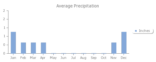
The Polar Ice Fields are a polar desert located at the northern most point on the planet. The existence of ice sheets in this region is evidence that the world is still under an Ice Age, but have not been formally studied as to whether or not they are expanding or shrinking by nature. As it currently stands, the Polar Ice Fields exist as the world's largest desert, as it remains as a region that receives very little (less than 4 inches) precipitation annually due to the low humidity.
Location
The Polar Ice Fields are located at the northern pole of the world and reach down into Panguro in the northwestern hemisphere.
Climate
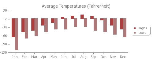
This region is one of radical temperature ranges at the lower end of the spectrum. In terms of highs, the maximum temperature reached within the ice fields in the summer is 50° F, while the lowest temperature in the winter is −130 °F. During the summer months, solar radiation hits the surface of the ice fields at unprecedented rates, due to the fact that there is no true "night" during this season. This is the primary reason for temperatures sometimes reaching above freezing. In the winter months, the opposite takes place in which the sun does not reach the ice fields for months at a time in some areas. Temperatures hence plunge into unforgiving levels.
Katabatic Winds
In mountainous regions along the ice fields, katabatic winds can often times travel at such fast rates that they heat up upon reaching a certain speed. At speeds at or in excess of 80-100mph, the winds essentially evaporate all ice and water, creating dry areas along the terrain.
Geography
 Polar Ice Fields landscape |
Nearly all of the Polar Ice Fields are covered in an ice sheet nearly one mile thick, which makes this region the largest reserve of freshwater in the entire world. Beneath the ice on the mainland continent lie extensive bedrock and gravel plains. Mountainous regions also exist along the continent, leading to some ice-covered dormant volcanoes. Activation of these volcanoes often leads to major disruptions in the stability of the ice sheets in the surrounding areas. Steam and ash caused by an eruption can easily lead to white out conditions.
Ice Sheets
The ice sheets covering this region are at least one mile thick, making the access of the bedrock or gravel plains below nearly impossible. This also raises the elevation of the continent the more inland one ventures. This, of course, is reason for the extreme temperatures lows experienced in winter months.
Dry Regions
The existence of katabatic winds often creates dry areas in which all ice and water are virtually evaporated from fast traveling winds that heat up conditions along the surface. This has led to the creation of valleys that are completely ice free and can not sustain many, if any, life forms through its lack of humidity or water. As such, any native animals that venture into these regions often die and become mummified in their shallow graves through desiccation.
Hypersaline Lakes
 A hypersaline lake |
Numerous lakes within the dry regions of the ice fields exist as hypersaline lakes, where their salinity can surpass that of the ocean's by virtually 14 times. As a result, these lakes never freeze, but often times leave massive sodium chloride deposits all over the surface of the surrounding area when katabatic winds cause them to evaporate.