Maps Archive: Difference between revisions
Jump to navigation
Jump to search
Nymphetamine (talk | contribs) |
Nymphetamine (talk | contribs) |
||
| Line 43: | Line 43: | ||
File:Pcove-incomplete.jpg|An incomplete map of Pirate's Cove, off the coast of [[Arangoth]]|alt=Incomplete map of Pirate's Cove | File:Pcove-incomplete.jpg|An incomplete map of Pirate's Cove, off the coast of [[Arangoth]]|alt=Incomplete map of Pirate's Cove | ||
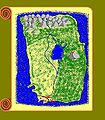
File:Pentland.png|[[Pentland]]|alt=Pentland | File:Pentland.png|[[Pentland]]|alt=Pentland | ||
File:Alesian-imperium.jpg|Cathor's map of the Alesian Imperium|alt=Alesian Imperium map | |||
</gallery> | </gallery> | ||
Revision as of 05:10, 13 February 2013
There's been a lot of maps made for use in the channel, many of which have been retired from active use due to revisions and updates made over time. They are collected here.
World
-
 The world map, drawn sometime after 2000
 -
 The world as of Jan 2000
 -
 The oldest world map, drawn prior to 2000


Veth


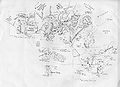
Arangoth
-
 Arangoth with provincial borders and major roads

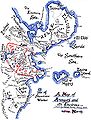
The Southlands


Miscellaneous
-
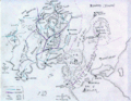
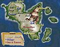 The Isles of Myst, a kingdom off the coast of Arangoth
 -
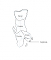
 An incomplete map of Pirate's Cove, off the coast of Arangoth
 -
-
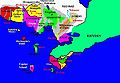
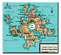 Cathor's map of the Alesian Imperium


