Maps Archive: Difference between revisions
Jump to navigation
Jump to search
Nymphetamine (talk | contribs) m Reverted edits by Stygian (talk) to last revision by Nymphetamine |
Undo revision 5526 by Nymphetamine (talk) |
||
| Line 3: | Line 3: | ||
=World= | =World= | ||
<gallery> | <gallery> | ||
File:Oldworld-1.jpg|The world map, | File:Oldworld-1.jpg|The world map, ca. 1997-1998|alt=old map 1997 or 1998 | ||
File:World-jan2000.jpg|The world as of Jan 2000|alt=old map from Jan 2000 | File:World-jan2000.jpg|The world as of Jan 2000|alt=old map from Jan 2000 | ||
File:Oldestworld.jpg|The oldest world map, drawn prior to 2000|alt=oldest world map | File:Oldestworld.jpg|The oldest world map, drawn prior to 2000|alt=oldest world map | ||
| Line 11: | Line 11: | ||
=Veth= | =Veth= | ||
<gallery> | <gallery> | ||
File:Original-veth.jpg|Original expanded map of [[Veth]]|alt=Map of Veth | File:Original-veth.jpg|Original expanded map of [[Veth]] from 2006|alt=Map of Veth | ||
File:Veth-political.jpg|Version of the 2006 Map with political boundaries highlighted.|alt=Political Map | |||
File:Northeast-map-2000.jpg|Northeast of [[Arangoth]], circa 2000|alt=Northeast of Arangoth | File:Northeast-map-2000.jpg|Northeast of [[Arangoth]], circa 2000|alt=Northeast of Arangoth | ||
File:Northwest-map.jpg|Northwest of [[Arangoth]], circa 2000|alt=Northwest of Arangoth | File:Northwest-map.jpg|Northwest of [[Arangoth]], circa 2000|alt=Northwest of Arangoth | ||
| Line 21: | Line 22: | ||
==Arangoth== | ==Arangoth== | ||
<gallery> | <gallery> | ||
File:Siramap.gif|Lysira's map of [[Arangoth]], created some time pre-1999. Used as the official map of the kingdom on the BDI site for years.|alt=Lysira's Map | |||
File:Arangoth-provincial-road.gif|[[Arangoth]] with provincial borders and major roads|alt=Arangoth map | File:Arangoth-provincial-road.gif|[[Arangoth]] with provincial borders and major roads|alt=Arangoth map | ||
File:Drache.jpg|One of the oldest maps of the city of [[Drache]]|alt=Drache map | File:Drache.jpg|One of the oldest maps of the city of [[Drache]]|alt=Drache map | ||
| Line 29: | Line 31: | ||
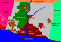
File:Elluria-tollor-pre-reunification.gif|An old map of [[Elluria]] and [[Tollor]] during the Civil War that resulted in the unification of Elluria|alt=Old Southlands map | File:Elluria-tollor-pre-reunification.gif|An old map of [[Elluria]] and [[Tollor]] during the Civil War that resulted in the unification of Elluria|alt=Old Southlands map | ||
File:Elluria-pre-tyranori-war.gif|[[Elluria]] before the Tyranori War|alt=Elluria before the Tyranori War | File:Elluria-pre-tyranori-war.gif|[[Elluria]] before the Tyranori War|alt=Elluria before the Tyranori War | ||
File:Tollorcity.gif|[[Tollor]] City in [[Elluria]] (this map does not reflect the current state of the region)|alt=Tollor City map | File:Tollorcity.gif|[[Tollor]] City in [[Elluria]] during the Tollorian Civil War (this map does not reflect the current state of the region)|alt=Tollor City map | ||
File:Mutoria-lithalle.gif|Mutoria & Lithalle, provinces of [[Aslar]]|alt=Mutoria & Lithalle map | File:Mutoria-lithalle.gif|Mutoria & Lithalle, provinces of [[Aslar]]|alt=Mutoria & Lithalle map | ||
File:El-ekki.gif|[[El-Ekki]], an island city of [[Elluria]]|alt=El-Ekki map | File:El-ekki.gif|[[El-Ekki]], an island city of [[Elluria]]|alt=El-Ekki map | ||
| Line 43: | Line 45: | ||
File:Pcove-incomplete.jpg|An incomplete map of Pirate's Cove, off the coast of [[Arangoth]]|alt=Incomplete map of Pirate's Cove | File:Pcove-incomplete.jpg|An incomplete map of Pirate's Cove, off the coast of [[Arangoth]]|alt=Incomplete map of Pirate's Cove | ||
File:Pentland.png|[[Pentland]]|alt=Pentland | File:Pentland.png|[[Pentland]]|alt=Pentland | ||
File:Alesian-imperium.jpg| | File:Alesian-imperium.jpg|Cathol's map of the Alesian Imperium|alt=Alesian Imperium map | ||
File:PanguiArchipelego.jpg|Map of the [[Panguro]] Archipelago|alt=Panguro Map | |||
</gallery> | </gallery> | ||
Revision as of 22:03, 19 June 2013
There's been a lot of maps made for use in the channel, many of which have been retired from active use due to revisions and updates made over time. They are collected here.
World
-
 The world map, ca. 1997-1998
 -
 The world as of Jan 2000
 -
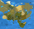
 The oldest world map, drawn prior to 2000


Veth
-
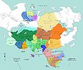
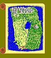
 Original expanded map of Veth from 2006
 -
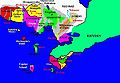
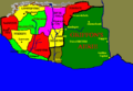
 Version of the 2006 Map with political boundaries highlighted.
 -
 Northeast of Arangoth, circa 2000
 -
 Northwest of Arangoth, circa 2000
 -
-


Arangoth
-
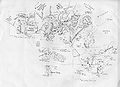
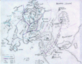
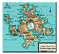
 Lysira's map of Arangoth, created some time pre-1999. Used as the official map of the kingdom on the BDI site for years.
 -
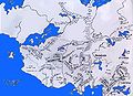
 Arangoth with provincial borders and major roads
 -
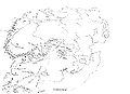
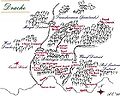 One of the oldest maps of the city of Drache


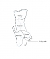
The Southlands


Miscellaneous
-
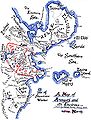
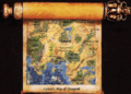
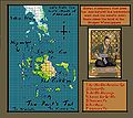
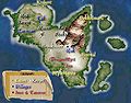 The Isles of Myst, a kingdom off the coast of Arangoth
 -
 An incomplete map of Pirate's Cove, off the coast of Arangoth
 -
-
 Cathol's map of the Alesian Imperium
 -
 Map of the Panguro Archipelago


