Maps Archive: Difference between revisions
Jump to navigation
Jump to search
No edit summary |
Nymphetamine (talk | contribs) |
||
| Line 23: | Line 23: | ||
File:Secca.gif|[[Secca]]|alt=Secca map | File:Secca.gif|[[Secca]]|alt=Secca map | ||
File:Leturia-ga.gif|[[Leturia]] & [[Griffon's Aerie]]|alt=Leturia & Griffon's Aerie map | File:Leturia-ga.gif|[[Leturia]] & [[Griffon's Aerie]]|alt=Leturia & Griffon's Aerie map | ||
File:Veth-physical.jpg|Veth physical map circa 2013 | File:Veth-physical.jpg|Veth physical map circa 2013, made by Pigasus | ||
File:Vethphysical2017.jpg|Updated physical map of Veth, Sept 2017 | File:Vethphysical2017.jpg|Updated physical map of Veth, Sept 2017, made by Pigasus | ||
</gallery> | </gallery> | ||
Revision as of 00:25, 23 July 2018
There's been a lot of maps made for use in the channel, many of which have been retired from active use due to revisions and updates made over time. They are collected here.
World
-
 The world map, ca. 1997-1998
 -
 The world as of Jan 2000
 -
 The oldest world map, drawn prior to 2000
 -
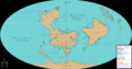
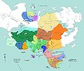
 Political world map from 2012
 -
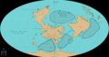
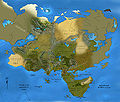
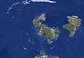 Physical world map from 2013
 -
 Climate world map from 2013
 -
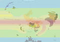
 Global trade routes map from 2016
 -
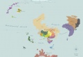
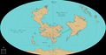 Updated political world map from 2017
 -
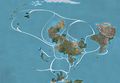
 Oceanic Trade Routes, by Uzzo, using Pigasus' world map (July 2018)
 -
 Siveth's ocean gyres, by Uzzo, using Pigasus' world map (July 2018)


Veth
-
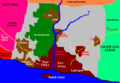
 Northeast of Arangoth, circa 2000
 -
 Northwest of Arangoth, circa 2000
 -
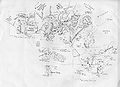
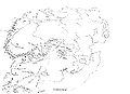
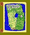
 Original expanded map of Veth from 2006
 -
 Version of the 2006 Map with political boundaries highlighted.
 -
-
-
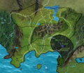
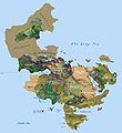 Veth physical map circa 2013, made by Pigasus
 -
 Updated physical map of Veth, Sept 2017, made by Pigasus


Arangoth
-
 Lysira's map of Arangoth, created some time pre-1999. Used as the official map of the kingdom on the BDI site for years.
 -
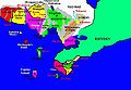
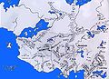
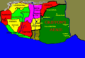
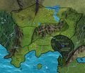
 Arangoth with provincial borders and major roads
 -
 A pronvicial map of Arangoth, created by Pigasus (Apr 2018)
 -
 A map of Arangoth's roads and regional trade routes, by Uzzo, using Pigasus' provincial Arangoth map (July 2018)


Drache
-
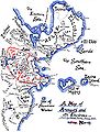
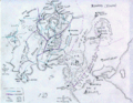
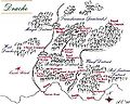 One of the oldest maps of the city of Drache
 -
 Another old map of Drache showing the districts of the city
 -
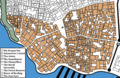
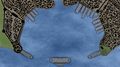 A close up view of the Drachean Harbor, created by Uzzo (Jan 2018)
 -
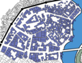
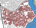
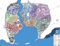 A new map of the city of Drache, created by Uzzo (July 2018)
 -
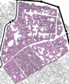
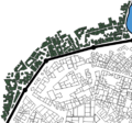
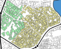
 The Blk Dragon District, created by Uzzo (July 2018)
 -
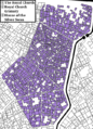 The Royal Church District, created by Uzzo (July 2018)
 -
The Diplomatic District, created by Uzzo (July 2018)
-
 The Gessi District, created by Uzzo (July 2018)
 -
 The Goblin Slums, created by Uzzo (July 2018)
 -
 The Ironworks District, created by Uzzo (July 2018)
 -
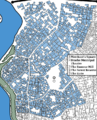 The Merchant District, created by Uzzo (July 2018)
 -
 The Mingit District, created by Uzzo (July 2018)
 -
 Western Drache, created by Uzzo (July 2018)
 -
The Wharf District, created by Uzzo (July 2018)
-
 Off the Coast of Drache, created by Uzzo (July 2018)


The Southlands


Miscellaneous
-
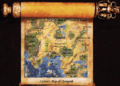
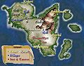 The Isles of Myst, a kingdom off the coast of Arangoth
 -
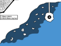
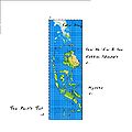
 An incomplete map of Pirate's Cove, off the coast of Arangoth
 -
-
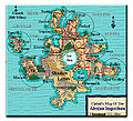 Cathol's map of the Alesian Imperium
 -
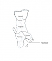
 Map of the Panguro Archipelago
 -
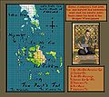
 Preliminary map of the Nipangu Archipelago


